


Townsville, North Queensland’s must-do walks – Wanders of wonder
By Carly Lubicz
Next time you’re here for an event, why not lace-up and head off the beaten track to explore a different side of Townsville, North Queensland? There are a huge variety of walking and hiking trails to discover, spanning from challenging rocky climbs to rainforest meanders and multi-day hikes. Here are just a handful of our must-try trails.
Many Peak Track | The Forts Walk | Mount Spec | Wallaman Falls | Thorsborne Trail
Many Peaks Track

Credit: Allison McKay
Where: Pallarenda, Townsville
Why: The heart rate and the views
How long: 3 hours/5.7km one way (you can return on the flat Lagoon trail – 2 hours/4.6km)
Many Peaks is a go-to for locals for its challenging terrain as much as the spectacular scenery. Accessed from the dirt track that starts opposite Walter Nesbit Park at Pallarenda, this heart-starting 5.7km (one-way) trail snakes its way through different terrain including boulders, vine thickets and woodland. It ultimately takes you across the range and to the summit of Mount Marlow, where you’ll be glad you brought your camera.
Reclaim your breath while you drink-in views over the Town Common wetlands and along the coastline from the Palm Island group in the north to Cape Cleveland in the south. You can return the same way or via the Lagoon trail (the track that you entered on), which is easier and flatter (2 hours return) and passes wetlands with birds galore — you’ll appreciate the rest!

More info: http://www.nprsr.qld.gov.au/parks/townsville/about.html#many_peaks_track
The Forts Walk
Where: Magnetic Island, Townsville
Why: Koalas, sparkling ocean vista and fascinating WWII history
How long: 1.5 hours return/4km
Keen to see a koala? Magnetic Island has the largest wild koala colony in Australia, and the Forts Walk — with its resident marsupials often in plain sight along the main trail, coupled with spectacular views and fascinating history — is one of the region’s most popular walks.
The Magnetic Island Forts Walk starts at the turn-off to Radical Bay on Horseshoe Bay Road and is 4km, or 1.5 hours return (graded moderate). It offers breathtaking 360-degree views of the coast and Coral Sea, plus intriguing WWII history with gun emplacements, an observation tower and a command post.
There are some rocky uphill sections so wear decent footwear and bring water. If you want to keep going, you can actually reach Horseshoe Bay via a coastal walk that showcases breathtaking boulder-lined bays (2 hours/7.5km). There are plenty of fantastic trails on the Island — another fave is Nelly Bay to Arcadia (2.5 hours/5km).
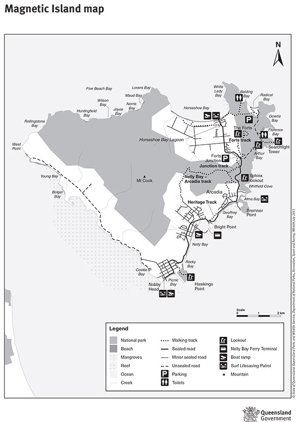
More info: http://www.nprsr.qld.gov.au/parks/magnetic-island/about.html.
Mount Spec walks

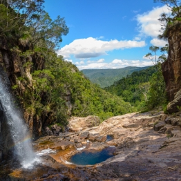
Paluma Cloudy Creek Waterfalls
Where: Paluma Range National Park, 71km north of Townsville
Why: Rainforest discovery in cool bliss
How long: Various – 300m to 4km
If you’re visiting during the warmer time of year, Paluma — otherwise known as the ‘village in the clouds’ — offers a wonderful respite from the humidity. Being part of the Wet Tropics World Heritage Area, it also happens to have some pretty amazing rainforest trails that suit walkers of all levels, ranging from 300m to 4km.
The national park itself contains five Queensland Parks and Wildlife Service walks, which are clearly signposted and have interpretive signs about the history of the area (tin, timber and a WWII radar station), plus diverse wildlife and rainforest habitat. There are also two short community walking tracks through the Paluma township showcasing logging relics.
Of the longer walks, the moderately-graded Cloudy Creek is well-worth a look. At 4km return, it starts 200m beyond McClelland’s lookout and takes you to Witts lookout, where — on a clear day — you can see out to Halifax Bay and the Palm Islands. To continue to Cloudy Creek from here, you need to follow the track to the left, which takes you further into the rainforest to a series of small waterfalls. A word of warning — some sections of this walk are steep and require careful boulder hopping.
Make sure you have a refreshing dip in Big or Little Crystal Creek on the way back down.
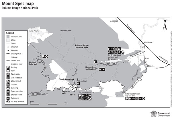
More info: http://www.nprsr.qld.gov.au/parks/paluma-range/
Wallaman Falls
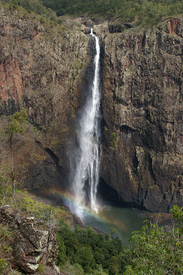
Where: 51km west of Ingham
Why: Australia’s highest sheer drop waterfall
How long: Djyinda Walk 2 hours/3.2km return
Although it takes a little while to reach the Wallaman Falls section of Girringun National Park along the twisty and partially unsealed road, the awaiting scene makes the drive well-worth it. Not only can you watch the crystal-clear water tumbling 305m — the escaping mist combining with sunlight and forming a rainbow against the brown jagged rocks — but there are also 110km worth of walks in the area, varying from 45 minutes to three days in length.
The two-hour Djyinda Walk offers a happy medium. It begins 300m from the Wallaman Falls lookout and winds through the open forest along the escarpment. There are views of the Herbert River Valley and the track eventually ends up at the base of the falls where you can look-up and see Queensland’s highest sheer-drop waterfall from a totally new perspective. It’s graded moderate because of its steep descent and slightly unstable surfaces, but just take your time on the way back up if you need to — another excuse for pics!

More info: https://www.npsr.qld.gov.au/parks/great-walks-wet-tropics-wallaman/
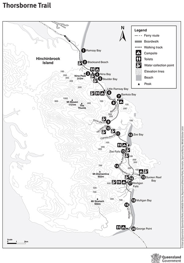
Thorsborne Trail
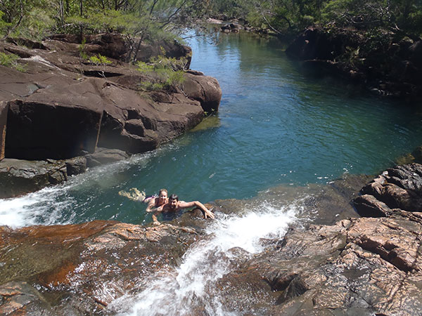
Where: Hinchinbrook Island, 8km east of Cardwell
Why: It’s described as a “holy grail for walkers” (Lonely Planet)
How long: Total trail is about four days, but you can do parts in a couple of hours
Described as a “landscape spectacular of sandy beaches, precipitous headlands, waterfalls, rugged mountains, mangrove forests, coral reefs, sheltered bays and dense rainforests” and surrounded by the waters of the Great Barrier Reef, this famous trail is on many experienced hikers’ bucket lists.
Thirty-two kilometres in its entirety and notoriously challenging; it’s recommended that hikers allow four days and three nights (minimum) to trek between Ramsay Bay and George Point to best appreciate the spectacular scenery and swim in the pinch-yourself-they’re-so-beautiful waterholes.
There are seven camp sites over the course of this technically difficult trail, but make sure you book and get your permit well ahead if you’re thinking of visiting during a peak period as numbers are capped.
But you don’t have to be a multi-day hiker to sample the Thorsborne Trail — you can do part of the walk, like George Point to Mulligan Falls (7.5km, or 2.5 hours hiking time — you can access George Point via water taxi). Or if you can get to Zoe Bay via a private vessel you will not be disappointed — scale to the top rock pool via a rope and you can cool off in a series of natural rock baths while looking out into Great Barrier Reef World Heritage Area. It doesn’t get much better!
More info: https://www.npsr.qld.gov.au/parks/hinchinbrook-thorsborne/about.html
Local tip
If you’re looking to take your exploration to the next level, Townsville Bushwalking Club which has organised walks exploring areas outside of the mainstream tracks. Check out their website: http://www.townsvillebushwalkingclub.com/